")

Our Projects:
We believe that geospatial data is more than maps – it is a foundation for clarity, planning, and security. Through drones, GIS, and digital twin modeling, we deliver solutions that help our clients act with confidence.

We are thrilled to announce that KondorCAD LandSurv has been selected as a finalist in the "Copernicus Border Surveillance Service Evolution Prize Contest," organized by Frontex, the European Border and Coast Guard Agency. Out of all the teams that entered, we are proud to be one of the three finalists, alongside talented teams from Spain and Poland. The final results are expected to be announced in September, when the top three places will be revealed.
Our Technical Expertise and Innovation
This
achievement highlights how we seamlessly blend our geodesy expertise
with cutting-edge technology. For our projects at KondorCAD LandSurv, we use:
- Digital Twin technology to create realistic and dynamic
models of the environment.
- Geospatial data from drones to achieve high accuracy, which
is essential for precise data analysis and representation.
- GIS technologies to ensure information is
integrated and interpreted efficiently.
This approach allows us to solve modern geospatial challenges and provide innovative solutions that have direct applications in border security and territory management.
A Dedicated Team and a History of Success
Even though our team is small, with just four members, each person's passion and dedication were key to this success. We have completed over 100 geodesy projects, solidifying our position as a trusted partner in the fields of surveying and geospatial solutions.
Representing Romania at a European Level
Being a finalist in the Frontex contest not only proves our team's professional skills but also showcases Romania's potential in the European geospatial sector. We are honored by this recognition and motivated to keep innovating, developing our skills, and contributing to advancements in surveying and geodesy.
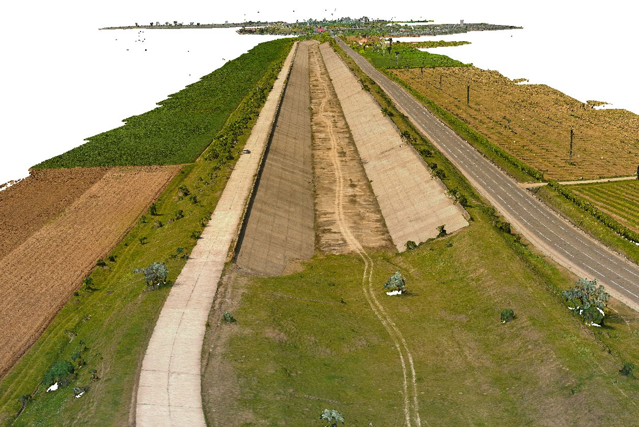
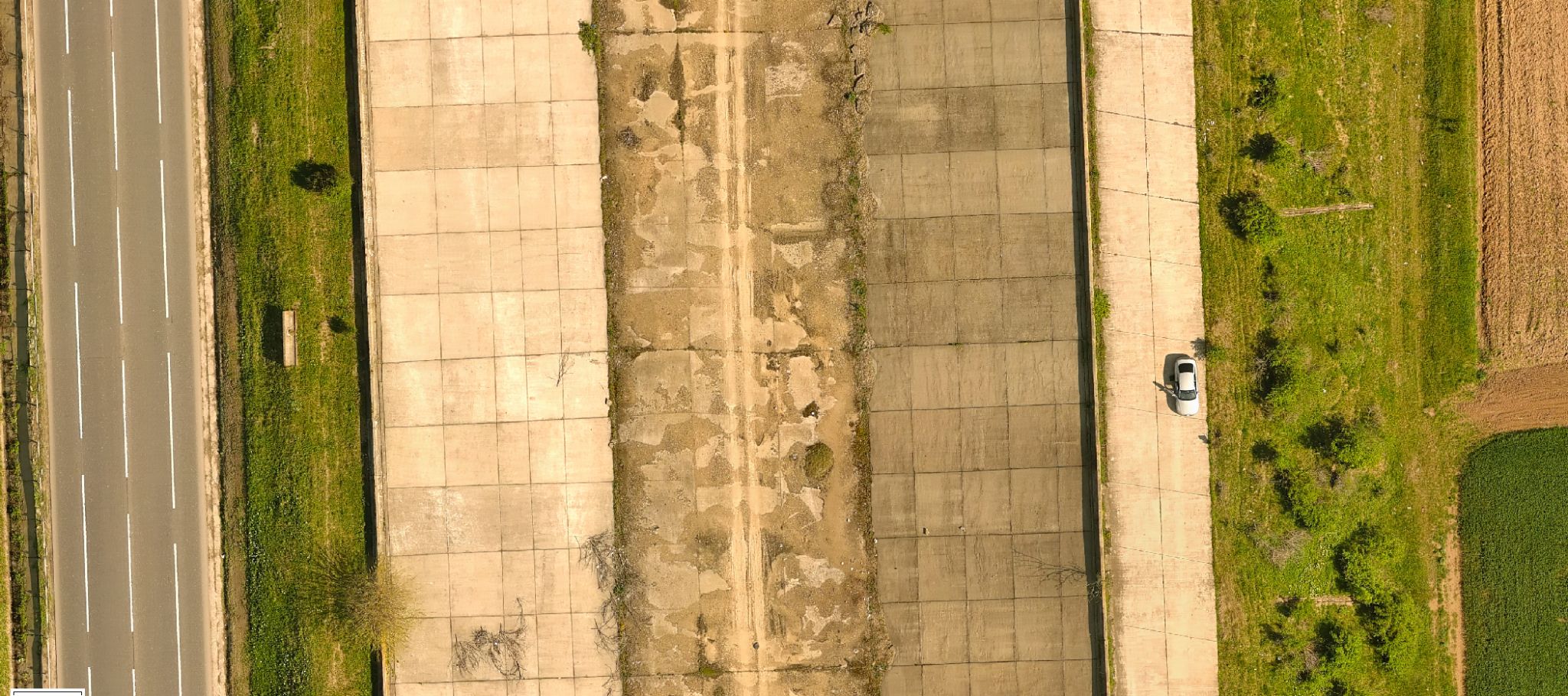
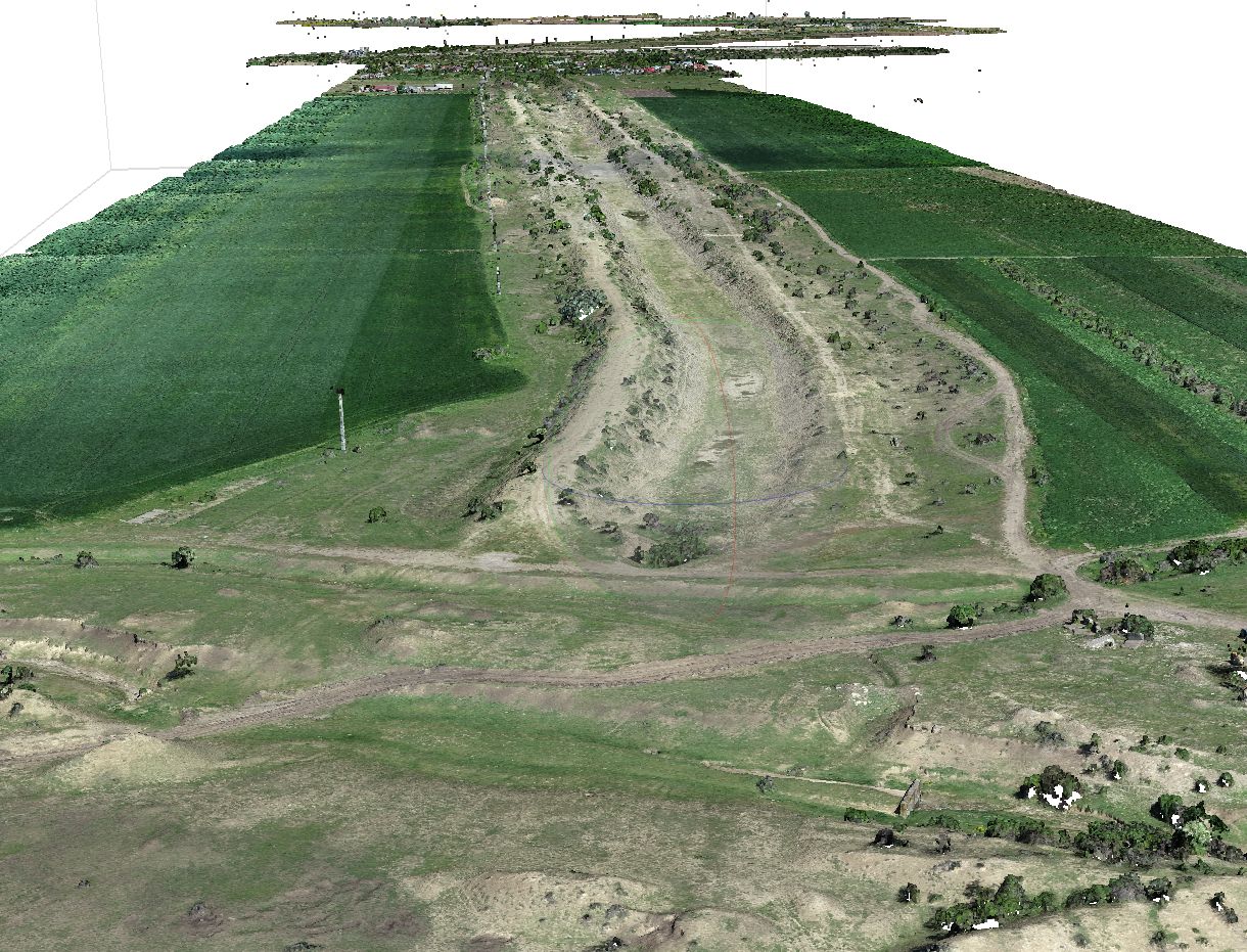
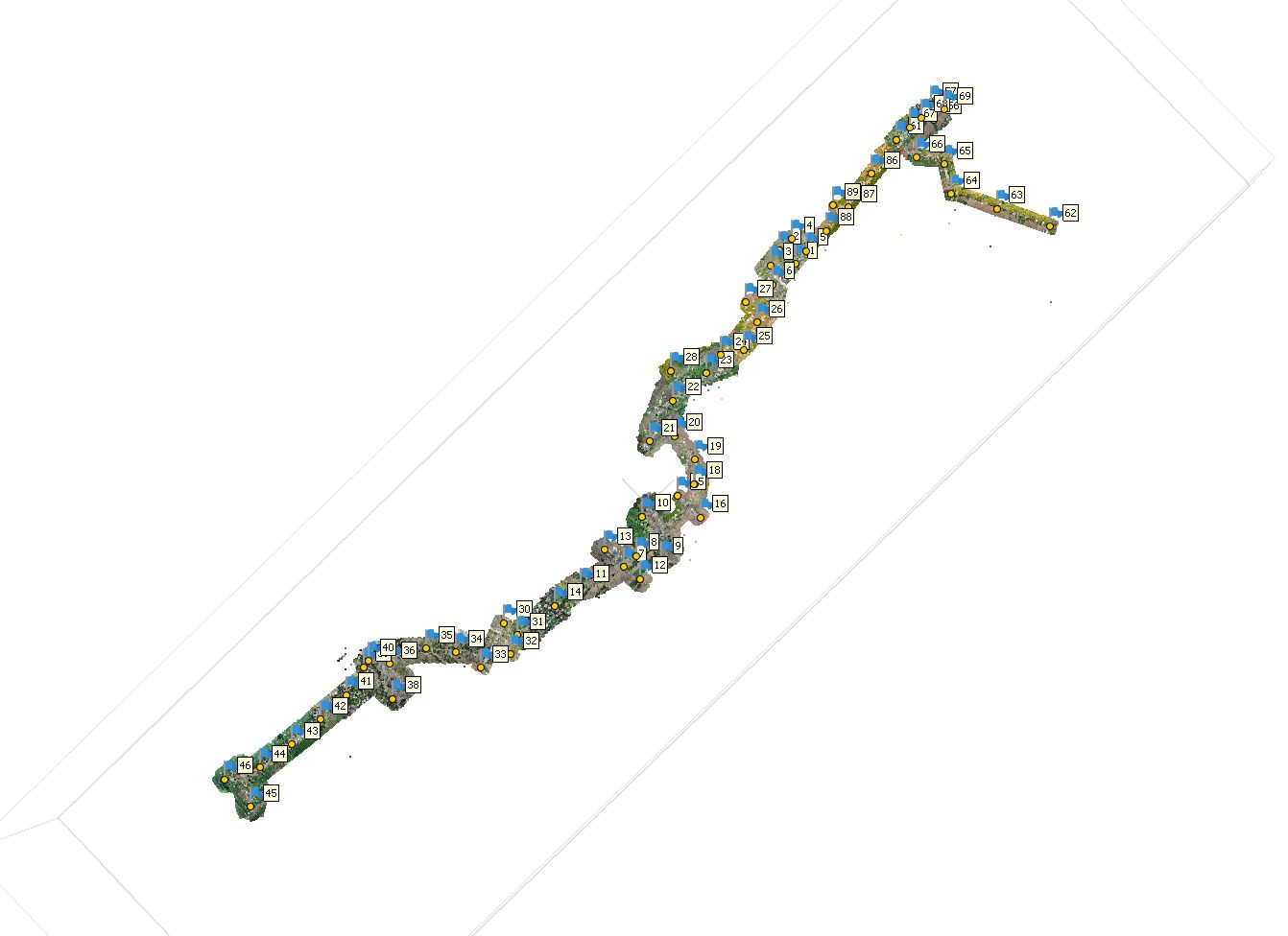
Fieldwork for the "Copernicus Border Surveillance Service Evolution Prize Contest"
As
part of the "Copernicus Border Surveillance Service Evolution Prize
Contest" organized by Frontex, the KondorCAD LandSurv team completed a
challenging practical phase that involved collecting and processing geospatial
data directly in the field.
A
Fictional Border and a Real-World Challenge
This practical exercise took place in Dubova, Mehedinți County, Romania. We were tasked with analyzing three fictional border sectors with a total length of 21 kilometers. To get precise data, our team went on-site and conducted an intense drone flight campaign.
Our
Methodology for Precision
- We completed over 35 drone
flights to cover the entire 21 km route.
- To create a highly accurate
orthophotomap, we placed Ground Control Points (GCPs).
- These were positioned every 500
meters, which allowed us to achieve a high degree of data precision.
Through this approach, we showed our team's ability to combine fieldwork with GIS technologies and aerial photogrammetry to produce high-quality geospatial products.
Adding Value Through Experience
This
stage was more than just a technical challenge; it was a chance to show how our
team's experience from past projects translates into a real-world,
international context. With a team of four specialists and over 100 completed
projects, KondorCAD LandSurv continues to demonstrate professionalism and
consistency in the fields of geodesy and geospatial solutions.
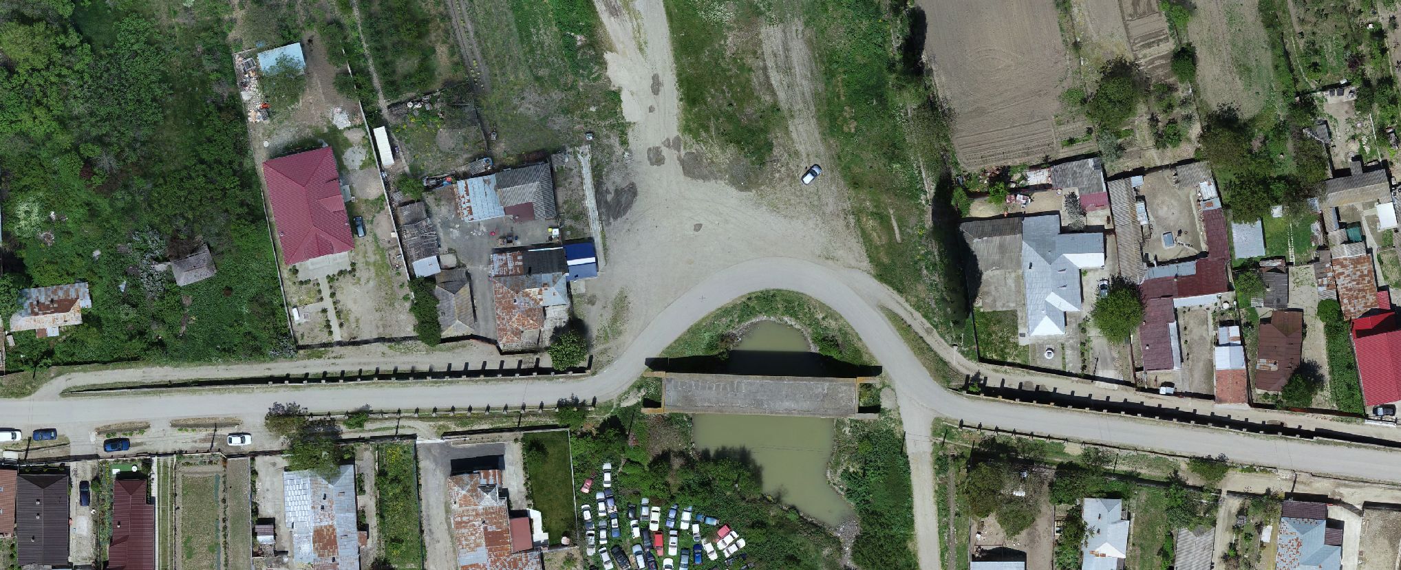
Modern Tech for Rebuilding the Siret-Baragan Canal
Main
Event: Rebuilding a
massive canal - Section 0-23km of the Siret-Baragan Canal
To build big projects, you need very precise data. Recently,
the KondorCAD team worked on a major project in Vrancea, covering 23 km of the
Siret-Baragan Canal. Our goal was to use drones and modern technology to gather
information about the land, to help with the canal's rebuilding.
The goal was clear: create digital maps and land models that
give a complete and exact picture.
How We
Did It
To measure the land with precision, we used a Phantom 4
Pro v2 - RTK drone. Our flights collected valuable information, giving us
exact reference points and a detailed profile of the canal.
With the drone, we went beyond traditional measurement
methods, getting a clear and precise view of the area. The exact points help us
make accurate maps, and the detailed profile gives us a deep look into the
canal's features.
All this precise data helps us make good decisions and plan
efficiently. We covered a 23 km long and 150-meter wide area. We did about 25
flights, getting 10,000 aerial photos. These were processed with software like
DxO + Agisoft Metashape and many ground control points (GCPs), reaching a
precision of about 2.5cm.
What We
Used
- DJI Phantom 4 Pro v2.0 Drone: It captured over 11,200
high-quality images, giving us a clear view of the land, even in
hard-to-reach places.
- Geomax Zenith 35Pro GNSS System: We used it for exact ground
measurements. We placed 89 Ground Control Points (GCPs) to make sure the
aerial images had perfect coordinates.
- Software:
- Drone Harmony: To plan the flights.
- Pix4D: To turn the images into maps,
3D models, and point clouds.
- TopoLT/ProfLT: To create the canal's
profiles, which are important for planning.
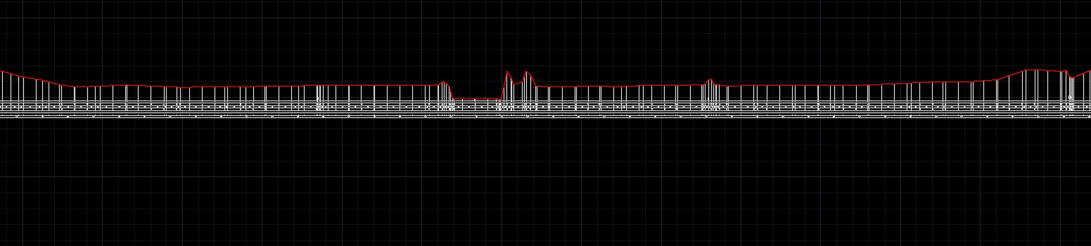
Our
Results
- High-resolution photo maps: Accurate down to 3 cm.
- Dense 3D point cloud: Useful for measuring volumes
and running simulations.
- Profiles: We created cross-section and
longitudinal profiles every 50 meters, which help us better understand the
land.
- Topographic maps: With contour lines, especially
useful where the canal crosses rivers.